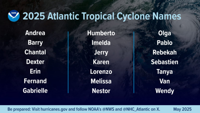
Today marks the official beginning of hurricane season in the North Atlantic basin, lasting through the end of November.
While tropical cyclones can form at any time of the year, activity typically begins to increase during late spring and lasts through much of the fall.
The peak of the season runs from around mid-August to roughly mid-October.
An average Atlantic hurricane season, based on data from 1991-2020, features fourteen named storms, seven hurricanes, and three major hurricanes.
Despite only a few tropical cyclones making any direct impacts on North Carolina, last year will arguably go down as one of the most memorable in history.
After a pre-season lull, activity ramped up in the latter stages of the summer and into early fall, as the Atlantic basin saw 18 named storms in 2024 with winds of 39 mph or greater.
Eleven of those were hurricanes and five intensified to major hurricanes with sustained winds of 111 mph or higher.
Five hurricanes made landfall in the continental U.S., with two storms making landfall as major hurricanes.
While there were no active tropical depressions, tropical storms or hurricanes to take a path over the region this season, there was still plenty to be felt from a number of systems.
Remnants of Debby dumped up to 8 inches of rain in early August across the region, and caused flooding issues in northern Duck, mainland Currituck and on Hatteras Island.
The only watch or warning posted for our region last season was from Potential Tropical Cyclone #8, when a Tropical Storm Warning from Ocracoke Inlet south was issued on September 15.
High surf from that system, which came ashore along the South Carolina coast, caused overwash along N.C. 12 on Ocracoke Island and between Hatteras and Frisco.
PTC #8 also dropped more than 10 inches of rain on the northern Outer Banks, causing flooding in numerous neighborhoods in Corolla, Sanderling and Duck.
And as is typical during most seasons, distant offshore hurricanes created overwash and rip current issues at times along the Outer Banks beaches.
Ernesto in mid-August caused a house to collapse and damaged other oceanfront structures in Rodanthe, and exposed more infrastructure and contaminated sand along Buxton Beach.
Other distant hurricanes, Kirk and Milton, in October also caused overwash and erosion from Oregon Inlet to Ocracoke.
But it was Hurricane Helene that left the biggest mark on the state in generations.
The storm made landfall as a Category-4 storm on the Florida Gulf Coast on September 26.
As it came ashore, it began to interact with a stalled cold front, causing catastrophic flooding across the southern Appalachians, widespread wind damage from the Gulf Coast to the North Carolina mountains and storm surge flooding along portions of western Florida.
Between 12 and 31 inches of rain fell over the western third of the North Carolina within a 72-hour period, and produced flooding that rivaled previous high water marks set in 1916.
Preliminary data indicate that Helene was the deadliest hurricane to affect the continental U.S. since Katrina in 2005, with more than 150 direct fatalities including 103 in North Carolina.
Damage estimates across 25 counties of the state have topped $58 billion, making it the costliest hurricane in North Carolina history.
Hurricane Helene marked the first time ever that NOAA’s National Hurricane Center forecasted a system to become a major hurricane before it became a tropical depression or tropical storm.
NWS was forecasting extreme rainfall totals and rates over western North Carolina more than 48 hours in advance.
Preseason predictions for 2025 are calling for an above-average season of activity, according to researchers and forecasters at NOAA, N.C. State University and Colorado State University.
Dare County Emergency Management Director Drew Pearson told Coastal Review in an email that he echoed National Weather Service Director “Ken Graham’s statement in the NOAA release where he says ‘This outlook is a call to action: be prepared. Take proactive steps now to make a plan and gather supplies to ensure you’re ready before a storm threatens’.”
Graham’s “words are true even when the predictions are for a less active season. No matter how many storms are being predicted, everyone needs to be prepared for that one storm that will put them in harm’s way,” Pearson continued.
“I would be remiss if I didn’t encourage everyone to never focus on just the category of a tropical storm,” he said. “Any storm system is dangerous and can bring life threatening impacts from storm surge, rainfall flooding, wind, tornadoes and rip currents. Just the other afternoon we had a tornado in Wanchese during a severe thunderstorm.”
“With our area’s susceptibility to tropical systems, preparation each and every year is crucial,” said Erik Heden, National Weather Service Newport/Morehead City Office Warning Coordinator Meteorologist.
“It only takes one storm to make an impact on our lives,” Heden said. “While many of us have experience with hurricanes, we must remember people continue to relocate to our area each year and they may not have any experience with hurricanes!”


