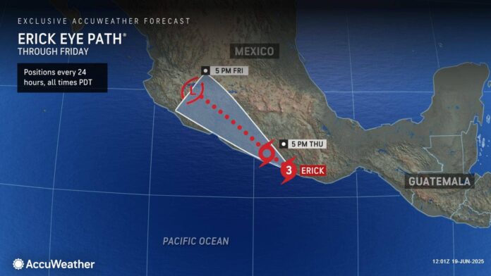
Erick will go down in the record books as the first major hurricane to strike Mexico during the month of June, blasting the region with destructive storm surge, extreme wind gusts and torrential rainfall.
Hurricane Erick made landfall along the coast of southwestern Oaxaca in southern Mexico around 8 a.m. EDT as a major Category 3 hurricane on the Saffir-Simpson Hurricane Wind Scale with maximum sustained winds of 111-156 mph. “Erick has been moving through an area with exceptionally warm ocean waters, plenty of moisture and very little disruptive wind shear. This was the perfect environment for Erick to explode from a tropical storm to a Category 4 hurricane in less than 24 hours before making landfall,” AccuWeather® Lead Hurricane Expert Alex DaSilva. “Rapid intensification near coastal cities is a major concern this hurricane season. This is a trend we expect to see happen more often as water temperatures continue to increase.”
DaSilva said Hurricane Kiko was previously the earliest major hurricane on record to make landfall in the eastern Pacific on Aug. 27, 1989.
Erick is forecast to bring damaging winds, heavy rain and storm surge impacts to parts of southern Mexico as it tracks inland Thursday into Friday.
AccuWeather® hurricane experts say this heavy rainfall will lead to life-threatening flash flooding and mudslides. Erick will also continue to bring dangerous waves and rip currents to the Mexican coastline this week. Areas in and around Acapulco are especially vulnerable to tropical impacts, as many areas are still recovering from Hurricane Otis that impacted the area in 2023. Heavy rain will continue across portions of southern Mexico as Erick moves northwestward. A wide swath of 1-2 inches of additional rain is expected from western Chiapas and Veracruz through Jalisco and southern Nayarit. A swath of 4-8 inches of additional rain will extend from central Oaxaca through southern Michoacan and far southeastern Colima.
The heaviest rain will fall across southern Oaxaca and southeastern Guerrero where 8-16 inches of additional rain is expected with an AccuWeather Local StormMax™ of 20 inches. Hurricane Erick will produce maximum sustained winds of 39-73 mph across portions of the Mexican states of Oaxaca and Guerrero, with stronger sustained winds up to 130 mph closer to where the storm made landfall. Wind gusts of 40-80 mph are expected across Oaxaca, Guerrero and southeastern Michoacan throughout the day as the storm moves inland.
These winds can bring down trees and power lines and cause significant structural damage. Erick is expected to bring 1-3 feet of storm surge from Acapulco to eastern Oaxaca. Near where the storm made landfall to Puerto Escondido, an area of 6-10 feet of life-threatening storm surge is anticipated.
Due to life-threatening flooding rainfall, damaging winds and a dangerous storm surge, Erick is a 4 on the AccuWeather RealImpact™ Scale for Hurricanes in Mexico. A 4 on the AccuWeather RealImpact™ Scale for Hurricanes warns of widespread catastrophic flooding that may last days to weeks, widespread power outages, structural damage to many buildings, especially near the coast, as well as severe coastal inundation.
In contrast to the Saffir-Simpson Hurricane Wind Scale, which classifies storms by wind speed only, the AccuWeather RealImpact™ Scale is based on a broad range of important factors. In order to better communicate a more comprehensive representation of the potential impact of a storm to lives and livelihoods, the scale covers not only wind speed but also flooding rain, storm surge and economic damage and loss. Some of these hazards, such as inland flooding and storm surge in many storms, result in more deaths and economic loss than wind.
AccuWeather® hurricane experts are highlighting a low risk for tropical development west of Panama next week. AccuWeather® hurricane experts are forecasting 14-18 named storms in the eastern Pacific this season. AccuWeather® forecasts three to five of those named storms to strengthen into major hurricanes. AccuWeather’s Eastern Pacific Hurricane Season Forecast predicts three to six direct impacts to Mexico and Central America. AccuWeather® hurricane experts say no tropical development is expected in the Atlantic basin over the next week due to vast areas of dry air, Saharan dust and disruptive winds, which are typical during the early weeks of the Atlantic hurricane season.


